The road network of Tahuantinsuyo (in Quechua, Qhapaq Ñan or Inka naani) was an enormous distance system of roads in the Inca civilization that connected important cities on the coast and in the highlands.
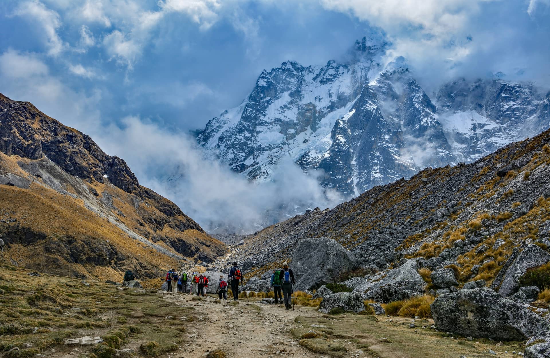
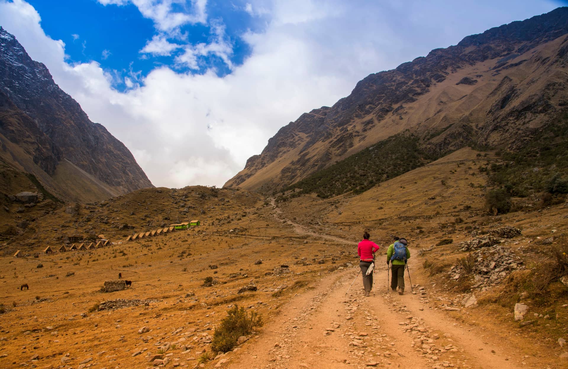
It was structured based on two longitudinal axes: the cordilleran sector and the flat coastal sector. Currently, visitors can visit a portion of the Andean network by going through any of the Inca Trail tours, wether if it's the short Inca Trail 2 days tour, the one day Inca Trail tour or the classic Inca Trail 4 days tour.
This Inca system was a millennial legacy of pre-Inca cultures, empowered during the Inca State. In the Quechua language, Qhapaq Ñan means: road of the king or of the powerful, referring both to the entirety of that network of routes, which exceeded 30,000 kilometers, as well as to the main road (approximately 5,200 km long). All of these roads were connected to Cusco, the capital of Tahuantinsuyo or the Inca Empire, facilitating communication with the different annexed peoples within the framework of the Inca expansionist process and, at the same time, constituting an effective means of political-administrative, socio-economic and cultural integration. Since the Qhapaq Ñan interconnected localities as distant as Quito, Cusco and Tucumán, the Spanish conquerors used it during the 16th century to invade Peru, Bolivia, Chile and the Argentine Cordilleran plateaus.
The famous "Inca Trail", which connects the city of Cusco with the historic sanctuary of Machu Picchu, is only a minimal intra-regional part of the gigantic Qhapaq Ñan network.
Network in South America
Starting from Cusco, the Qhapaq Ñan allowed travel through the four "suyus of the Inca empire" (from the Quechua suyu: 'region' or 'territory') that constituted Tahuantinsuyo:
- to the north the Chinchaysuyo, occupied by groups such as the Chincha, Chimu or Yungas and Pastos;
- to the southeast the Collasuyo, occupied by Aymaras, Qollas and Puquinas;
- to the southwest the Contisuyo, occupied by groups such as the Conti or Conde, Collaguas and settlers of Puquina origin;
- to the east the Antisuyo, occupied by the Antis (the current native populations of the Amazon).
The Qhapaq Ñan enabled the economic and political control of these peoples. At the same time, it allowed for their integration, exchange and state mobilization of various products, the transmission of cultural values, access to different Inca shrines and the development of common practices; it was also a symbol of Cusco imperial power and its expansion throughout the South American geography, which included six current Andean countries: Argentina, Bolivia, Chile, Colombia, Ecuador and Peru.
With a total length of 60,000 kilometers, this skillfully constructed backbone by the hands of specialists can be compared, in its dimensions, to the Silk Road or the Great Wall of China.
History
The road between the temple of Pachacamac and Apu Pariacaca predates the Inca conquest. Although there were several roads built by complex civilizations, it was during the Tahuantinsuyo that the road network notably increased. The photo shows part of the staircase that rose to the snowy Pariacaca.
Inca road. Much of the Inca Trail and some transverse road networks were covered by stone blocks or slabs.
The Roads before Tahuantinsuyo
Several of the roads currently observed in the Andean area occupied by Tahuantinsuyo had a pre-Inca origin, having been built by highly complex political entities such as Tiahuanaco or Huari; other minor roads, however, were built by small ethnic groups that tried to connect places of worship or regional temples. Such is the case of the road built between the temple of Pachacamac (facing the sea) and the "apu" Pariacaca, a snow-capped peak located at more than 5,700 meters above sea level.
The quantity and length of the roads in the pre-Inca era was limited by the constant tensions and warlike environment experienced by the lordships and states; road construction was dangerous and only some sections were built during periods of truce. Before the arrival of the Incas, the roads were exclusively local; it was only with their arrival and centralizing power that the road network expanded to great magnitudes.
The Roads during Tahuantinsuyo
When the Incas began conquering the rest of the Andean peoples, the dominion of space for road construction was entirely at the disposal of the Cusco ethnic group; from this moment on, the road networks increased exponentially until covering an extension that possibly reached 60,000 kilometers.
The beginning of the great road works was carried out by express order of the Inca Pachacutec. This sovereign saw the need to build roads with the aim of maintaining control over the annexed territories, so that officials and troops could be moved more quickly.
As Juan de Betanzos points out, before Pachacutec began his reign, he was observed painting and drawing roads and bridges, specifying to the Cusco noblemen the way they should be built. Pachacutec's work was continued by his successors. The Inca road network consisted of three basic elements: the roadways and edges of the roads, the bridges and the warehouses.
The road network was indispensable for the Inca organization, not only to move armies and officials but also for the mobilization of the "mitimaes", the transport of products harvested in the territories conquered by the Incas (in each territory there were lands specifically destined for their production to be transported to Cusco; these harvests were stored in the "tambos") and the movement of the "chasquis" (messenger runners).
The Qhapaq Ñan and Other Roads
Being the main trunk of the entire Inca road network, the Qhapaq Ñan stood out for running longitudinally throughout Tahuantinsuyo (the Inca Empire) along the Andean mountain range, from the current western Argentina to southern Colombia. The Inca Trail is paved for much of its length and is several meters wide. Parallel to the Inca Trail, there was a road that connected the coastal towns, which at that time were called "yungas".
This coastal road was connected to the Qhapaq Ñan by several transverse roads that even reached the jungles and the Gran Chaco (Argentina, Bolivia and Paraguay). In the case of the coastal road, it was not paved but its edges were delimited.
The Spanish chroniclers described the Qhapaq Ñan with praise, some extolling its "excellent" functioning while others highlighted its straightness in some sections and its cleanliness, adding that they could cover great distances in a short time and with minimal effort. According to Bernabé Cobo, the Inca roads narrowed when passing through valleys and ravines, and the chronicler described that the roads had high walls that in some cases had animals and monstrous beings painted on them; these walls served so that the armies could pass without damaging the crops.
It is known that the "curacas" (local chiefs) were obliged to order the maintenance of the roads near their domains, clearing the accumulation of soil on the roads, repairing the paving and cleaning the ditches that protected the roads. The appearance of the roads when leaving the valleys was different, since the roads became wider and it was very common to see piles of stones that marked the steep points between the hills, these piles were called "apachetas". As noted by George Squier between 1863 and 1865, that old custom of leaving stones on the difficult slopes of the Inca roads turned them over time into markers, like milestones, that demarcated these roads.
To deal with muddy areas, it was necessary to build a base made of rough stone joined with a clay mortar that was finally covered with sod, forming an embankment. Below this embankment, drainage channels were made to eliminate excess water. For steep slopes, they built staircases or zigzagged the roads.
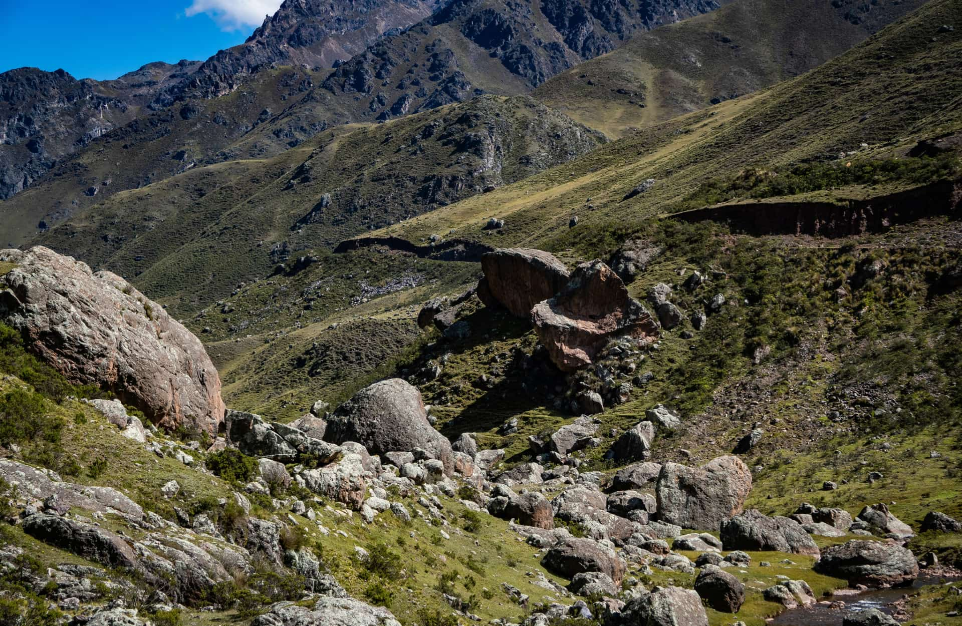
In general, there was no single design pattern for the Inca roads; rather, they adapted to the topography they crossed. The layout depended largely on factors such as the population density of the areas to be connected or the economic importance of the site to which the road was headed. And, although it is true that the Incas preferred to lay out their roads in a straight line, the rugged terrain forced them to delineate their roads avoiding obstacles.
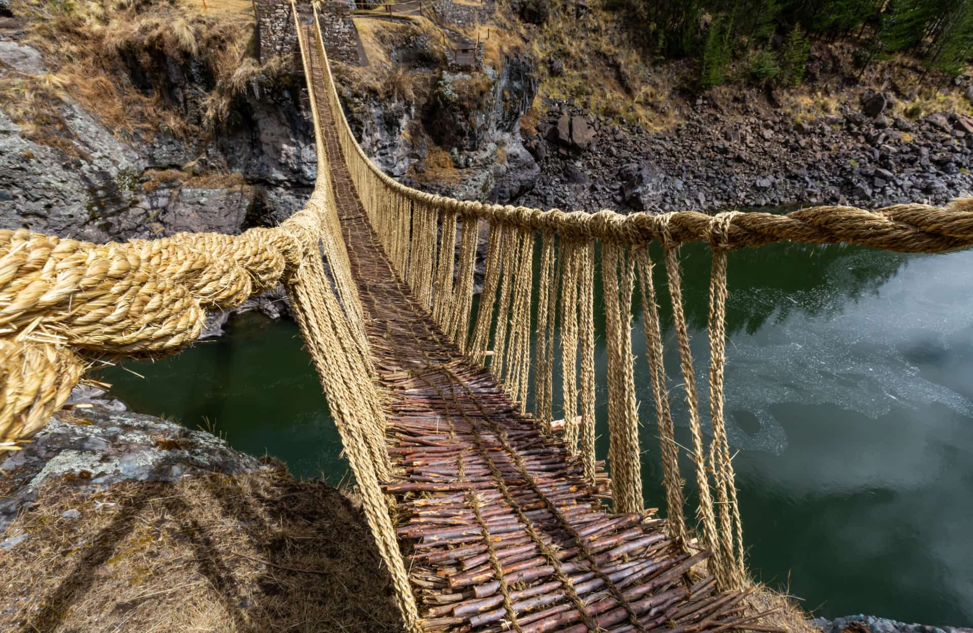
Bridges
The Q'eswachaca hanging bridge made of an ichu fiber called "qoya ichu". The renewal of this bridge is done through a 4-day ritual that has been maintained since the Inca period.
The construction of bridges became indispensable due to the Andean geographical reality. The most common bridges were those made with tree trunks and those made by braiding various fibers. In the case of trunk bridges, they were only used in places where the geography allowed it, and for this, a stone base was needed (two opposing rock outcrops) that were carved so that the logs would fit snugly. In the early colonial times, Miguel de Estete stated that at the exit of Huánuco Pampa there was a bridge made with thick logs, while near Cajamarca there was a bridge made with stone bases and very thick logs.
Hanging bridges were the most common in the Andean region. They were built with plant fibers that were attached to solid stone bases on each side; these fibers were braided to form cables 50 or 60 centimeters in diameter, and to pass the cord from one place to another, a thinner hemp rope called "chahuar" was used. The fiber for the bridges varied by region - they could be made of wicker, tasca (Escallonia patens), lloque (Kageneckia lanceolata), ichu (Stipa ichu) or chachacomo (Escallonia resinosa); in some areas the so-called "Chilca shrub" (Baccharis latifolia) was used. In areas where there were no shrubs, maguey (Furcraea andina) fiber was also used, a fiber also known as "pita" or "cabuya". In some cases the bridges had laid tree trunks to facilitate transit, but most often they had woven or intertwined fibers.
It should be noted that most of the Inca bridges were burned during the civil wars between the Spanish conquerors and the Manco Inca uprising. The French Account of the Conquest (written in 1534) describes that in the Indies there were powerful rivers from which bridges of thick ropes hung, and that there were bridges where the great lords passed and others where the common people passed.
The rivers could also be crossed by means of oroyas (also called tarabitas or huaros, depending on the region). Bernabé Cobo describes that these "tarabitas" were made with ichu ropes or vines as thick as a leg. These ropes were tied to rocks from one bank to the other and from them hung a basket, on which a person would sit and pull themselves across by the rope from one bank to the other.
In the case of the Desaguadero River, there was a floating bridge made by a row of totora reed rafts covered with various dry aquatic plants (including totora reeds). According to testimonies gathered by the chroniclers, this bridge over the Desaguadero was placed by order of the Inca Huayna Capac, who considered it unbecoming for his army to cross the river on rafts.
Kenko Adventures is a Cusco tour operator that offers the chance of covering the section of the Qhapaq Ñan known currently as the "Inca Trail".
Contact us to receive more information on your end and begin with your traveling plans in Peru with the most trustable agency in the region.


